
Surveying has been an essential practice for centuries, enabling the accurate mapping of land and guiding the construction of infrastructure. As technology has evolved, so too have the tools and techniques used by surveyors. One of the most significant advancements in recent years is the integration of Global Navigation Satellite System (GNSS) receivers into surveying processes. These high-precision GNSS receivers have transformed the field, offering unprecedented accuracy, efficiency, and reliability.
Understanding GNSS Receivers
GNSS receivers are devices that determine a precise geographic location by receiving signals from satellites in one or more satellite constellations, such as GPS (Global Positioning System), GLONASS (Global Navigation Satellite System), Galileo, and BeiDou. By triangulating signals from multiple satellites, a GNSS receiver can calculate an object’s exact position on the Earth’s surface with remarkable accuracy.
High-precision GNSS receivers are particularly valuable in surveying, where even the smallest positional error can lead to significant discrepancies in measurements, boundary definitions, and construction layouts. These receivers are equipped to handle the demands of professional surveying tasks, offering features like multi-frequency capabilities, support for multiple satellite constellations, and advanced error correction techniques.
The Role of High-Precision GNSS Receivers in Surveying
Enhanced Accuracy and Reliability
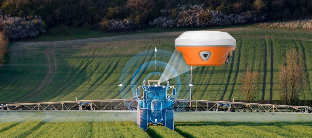
One of the most critical advantages of using GNSS receivers in surveying is the enhanced accuracy they provide. Traditional surveying methods, such as total stations and theodolites, rely on line-of-sight measurements and can be affected by factors such as terrain and atmospheric conditions. In contrast, GNSS receivers can achieve centimeter-level accuracy by using multiple satellite signals and applying correction techniques like Real-Time Kinematic (RTK) and Differential GNSS (DGNSS).
RTK, for example, involves using a stationary base station at a known location to calculate and broadcast real-time corrections to a mobile GNSS receiver. This method significantly reduces positional errors, making it ideal for tasks that require high precision, such as cadastral surveying, construction staking, and topographic mapping.
Check Also GNSS Receivers Increased Accuracy.
Increased Efficiency in Fieldwork
Surveyors equipped with GNSS receivers can complete fieldwork more quickly and with fewer personnel than with traditional methods. Because GNSS receivers do not require direct line-of-sight between the instrument and the object being measured, they can operate effectively in various terrains and environments, including forests, urban areas, and mountainous regions. This flexibility allows surveyors to cover larger areas in less time, reducing the overall cost and duration of surveying projects.
Additionally, GNSS receivers can operate continuously, regardless of weather conditions, further enhancing efficiency. Surveyors no longer need to wait for clear skies or optimal lighting conditions to perform measurements, allowing them to maximize productivity and meet tight project deadlines.
Versatility and Adaptability
High-precision GNSS receivers are versatile tools that can be adapted to a wide range of surveying applications. Whether conducting boundary surveys, topographic mapping, or construction layout, GNSS receivers provide the accuracy and reliability needed to achieve consistent results.
For example, in construction, GNSS receivers are used to guide automated machinery in tasks like grading and excavation. The precise positioning data provided by GNSS receivers ensures that these tasks are carried out according to design specifications, reducing the risk of errors and rework.
In environmental and natural resource surveys, GNSS receivers enable accurate mapping of land features, water bodies, and vegetation, providing critical data for conservation efforts and land management. Their ability to function in remote and challenging environments makes them indispensable for these types of projects.
Integration with Modern Surveying Software
GNSS receivers are designed to integrate seamlessly with modern surveying software, further enhancing their utility in the field. Surveying software allows professionals to collect, process, and analyze GNSS data in real-time, enabling immediate decision-making and adjustments during fieldwork.
For example, GNSS receivers can be connected to Geographic Information Systems (GIS) to overlay positional data onto maps, creating accurate geospatial representations of the surveyed area. This capability is invaluable for tasks like urban planning, infrastructure development, and environmental monitoring, where precise geospatial data is essential for informed decision-making.
Reducing Human Error
The use of GNSS receivers in surveying also helps reduce human error, which can be a significant source of inaccuracies in traditional surveying methods. Manual measurements and calculations are prone to mistakes, especially in complex or large-scale projects. GNSS receivers automate much of the measurement process, reducing the need for manual input and minimizing the risk of errors.
Additionally, GNSS receivers provide real-time feedback to surveyors, allowing them to identify and correct any issues immediately. This real-time validation ensures that measurements are accurate and consistent, reducing the likelihood of errors going unnoticed until later stages of the project.
Applications of High-Precision GNSS Receivers in Surveying
Cadastral Surveying
Cadastral surveying involves the precise measurement and mapping of land boundaries for legal purposes. Accurate boundary surveys are critical for property ownership, land division, and resolving disputes. High-precision GNSS receivers enable surveyors to determine boundary lines with centimeter-level accuracy, ensuring that property boundaries are defined correctly and legally defensible.
Topographic Mapping
Topographic mapping requires the accurate representation of the Earth’s surface, including its elevation and landforms. GNSS receivers are essential for capturing the precise coordinates and elevations needed to create detailed topographic maps. These maps are used in various applications, including environmental studies, infrastructure planning, and land development.
Construction Layout
In construction, GNSS receivers are used to guide the placement of structures, roads, and utilities according to design plans. High-precision GNSS receivers ensure that construction elements are placed accurately, reducing the risk of errors that could lead to costly rework or project delays. This precision is particularly important in large-scale infrastructure projects, such as highways, bridges, and pipelines.
Geodetic Surveying
Geodetic surveying involves measuring and mapping the Earth’s shape, orientation, and gravitational field. High-precision GNSS receivers are essential tools in this field, providing the accurate positional data needed for geodetic networks, tectonic studies, and monitoring land deformation. Geodetic surveys are critical for understanding the Earth’s dynamics and for applications such as earthquake monitoring and sea-level rise studies.
Environmental and Natural Resource Surveys
GNSS receivers play a vital role in environmental and natural resource surveys, where accurate location data is needed to map and monitor ecosystems, wildlife habitats, and natural resources. These surveys inform conservation efforts, land management practices, and resource extraction activities. The ability of GNSS receivers to operate in remote and challenging environments makes them indispensable for these types of projects.
Future Trends in GNSS Receivers for Surveying
The future of GNSS receivers in surveying is promising, with ongoing advancements that will further enhance their capabilities and applications.
Integration with Artificial Intelligence and Machine Learning
Artificial intelligence (AI) and machine learning are being integrated into GNSS technology to improve signal processing, error correction, and data analysis. These advancements will enable GNSS receivers to operate more efficiently and accurately, even in challenging environments. AI-driven GNSS receivers will be able to predict and compensate for signal degradation, ensuring consistent accuracy in all conditions.
Development of Multi-GNSS Receivers
Multi-GNSS receivers, capable of receiving signals from multiple satellite constellations simultaneously, are becoming increasingly common. These receivers provide greater satellite coverage, improving accuracy and reliability, especially in areas with limited visibility of the sky. The continued development of multi-GNSS receivers will further enhance their utility in surveying applications.
Miniaturization and Portability
As GNSS technology advances, receivers are becoming smaller, lighter, and more portable. This miniaturization allows surveyors to carry GNSS receivers more easily and use them in a wider range of applications. Portable GNSS receivers are particularly valuable in remote and difficult-to-access areas, where traditional surveying equipment may be impractical.
Enhanced Connectivity and Cloud Integration
Future GNSS receivers will offer enhanced connectivity and integration with cloud-based platforms, allowing for real-time data sharing and collaboration. Surveyors will be able to upload and access GNSS data from anywhere, streamlining the workflow and enabling faster decision-making. Cloud integration will also facilitate the use of GNSS data in large-scale projects involving multiple stakeholders.
Conclusion
High-precision GNSS receivers have revolutionized surveying techniques, offering unmatched accuracy, efficiency, and versatility. From cadastral surveys to construction layout and environmental mapping, GNSS receivers provide the precise positional data needed for a wide range of applications. As technology continues to evolve, the role of GNSS receivers in surveying will only grow, driving further advancements in accuracy, reliability, and efficiency. Surveyors equipped with the latest GNSS technology will be well-positioned to meet the demands of modern infrastructure development, land management, and environmental conservation.