Description
Applications of the M-2 GNSS Board
The versatility and precision of the M-2 GNSS board make it an excellent choice for a broad range of applications:
Surveying and Mapping: Achieve high accuracy in land surveying and cartography with reliable data that ensures precise measurements and detailed maps.
Precision Agriculture: Enhance crop management practices by utilizing accurate positioning for planting, spraying, and harvesting, leading to increased efficiency and yield.
Autonomous Vehicles: Provide reliable navigation and positioning data for autonomous drones, robots, and vehicles, ensuring safe and accurate operations.
Geotechnical Monitoring: Monitor infrastructure and natural hazards with high precision, ensuring timely data for decision-making and risk management.
Marine and Aviation Navigation: Ensure safe and accurate navigation for marine vessels and aircraft, even in remote or challenging environments.
Why Choose the M-2 GNSS Board?
When it comes to selecting a GNSS receiver, the M-2 GNSS board offers several advantages that make it a preferred choice for professionals in various industries:
Unmatched Accuracy: Achieve the highest levels of positioning accuracy, essential for applications where precision is non-negotiable.
Reliable Performance: Count on consistent and reliable data, even in conditions where other receivers might fail.
Ease of Integration: Benefit from a design that facilitates easy integration into existing systems, saving time and resources.
Future-Proof Technology: Stay ahead with a GNSS board that supports the latest advancements in satellite navigation technology.
Get Started with the M-2 GNSS Board
Ready to elevate your projects with the precision and reliability of the M-2 GNSS board? Contact us today to learn more about how this advanced GNSS receiver can meet your specific needs. Our team of experts is here to provide you with detailed information, technical support, and guidance to help you integrate the M-2 GNSS board into your applications seamlessly.
Discover the difference that precise and reliable GNSS technology can make. Choose the M-2 GNSS board for your next project and experience the pinnacle of positioning performance.
| Pin |
Signal name |
| 1 |
SDIO wake (output, 1.8 V level) |
| 2 |
UART_TXD (input, 1.8 V level) |
| 3 |
GLOBAL_RESET/SDIO_RESET (input, 1.8 V signaling, weak pull-up) |
| 4 |
UART_RXD (output, 1.8 V signaling) |
| 5 |
+3.3 V power output |
| 6 |
TP_TO_MOD/UART_RTS (input, 1.8 V signaling) |
| 7 |
+5.0 V power output |
| 8 |
TP_FROM_MOD/UART_CTS (output, 3.3 V signaling) |
| 9 |
Ground |
| 10 |
PM_WAKEUP_N/UART_WAKE_N (output, 3.3 V signaling) |
Multi-GNSS, Multi Frequency RTK/PPP Technology
- GPS (L1C/A, L1C, L1PY, L2C, L2P, L5)
- Galileo (E1, E5a, E5b, E5 AltBoc, E6)
- GLONASS (L1CA, L2CA, L2P, L3)
- Beidou (B1I, B1C, B2a, B2I, B3)
- QZSS (L1C/A, L1C, L2C, L5, L6)
- SBAS (Egnos, WAAS, GAGAN, MSAS, SDCM (L1, L5))
- On module L-band
Interfaces
Power supply:
- Input voltage: 3.3 VDC +/-5%
- Power consumption: 0.6 W typ, 1.1 W max
- Antenna bias voltage: 3.0-5.5 V, build-in current limit (150 mA)
Solution output protocols:
- Septentrio Binary Format (SBF)
- NMEA 0183, v2.3, v3.03, V4.0
- RINEX v2.x, v3.x
- RTCM v2.x, v3.x (MSM included)
- CMR v2.0 (out/in), CMR+ (input only)
Interfaces:
Multi-Constellation Support: The M-2 GNSS board supports all major GNSS constellations, offering improved satellite visibility and positioning accuracy even in challenging environments.
High Precision: With multi-frequency support, the M-2 GNSS board provides centimeter-level positioning accuracy, which is crucial for applications like land surveying, precision agriculture, and autonomous navigation.
Robust Performance: Engineered to perform reliably in various conditions, the M-2 GNSS board excels in environments where other receivers might struggle, such as urban canyons or densely wooded areas.
Compact and Lightweight Design: Its compact form factor allows easy integration into a wide range of devices and systems, without adding significant weight or bulk.
Low Power Consumption: The M-2 GNSS board is designed with energy efficiency in mind, making it suitable for battery-powered applications where power consumption is a critical factor.
Versatile Connectivity: With multiple interface options, the M-2 GNSS board can be connected to various systems and devices, providing flexibility and ease of integration.
What is the M-2 GNSS Board?
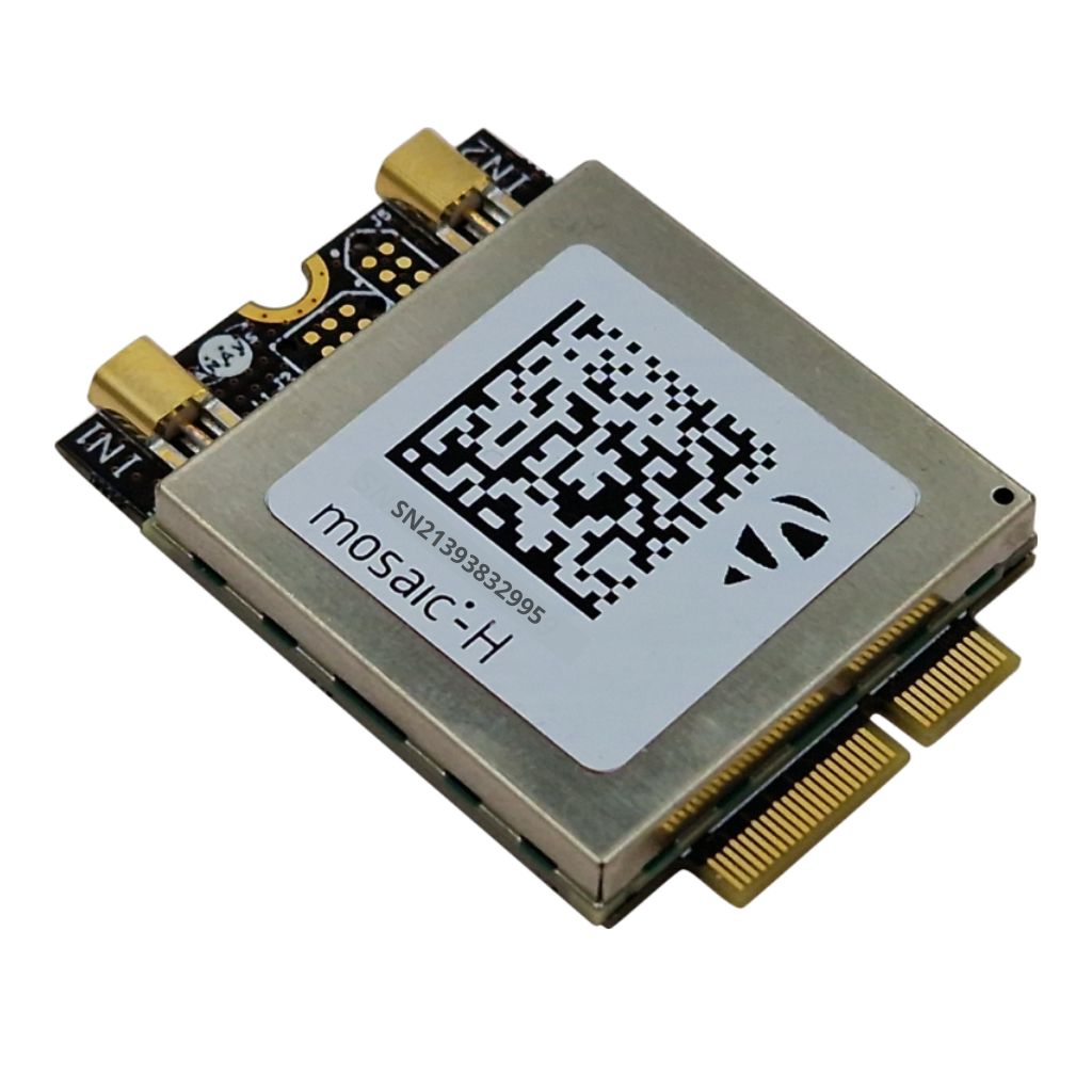
The M-2 GNSS Board is a high-precision, multi-frequency Global Navigation Satellite System (GNSS) module designed for applications requiring accurate positioning and navigation. It supports multiple satellite constellations and delivers reliable performance in various environments.
What satellite constellations does the M-2 GNSS Board support?
The M-2 GNSS Board supports multiple satellite constellations, including GPS, GLONASS, Galileo, and BeiDou. This multi-constellation support enhances positioning accuracy and reliability by providing more satellite signals for better coverage and redundancy.
What are the key features of the M-2 GNSS Board?
Key features of the M-2 GNSS Board include multi-frequency signal reception, high-precision positioning, robust performance in challenging environments, and low power consumption. It also offers easy integration with various applications through multiple interface options and is suitable for use in surveying, mapping, agriculture, and autonomous systems.
How can the M-2 GNSS Board be integrated into my project?
The M-2 GNSS Board is designed for easy integration with a variety of systems and applications. It comes with multiple interface options, such as UART, USB, and I2C, which allow seamless connection to microcontrollers, computers, and other devices. Comprehensive documentation and support materials are available to assist with the integration process.
What applications are best suited for the M-2 GNSS Board?
The M-2 GNSS Board is ideal for applications requiring high-precision positioning and navigation, such as surveying, mapping, agriculture, autonomous vehicles, and geospatial data collection. Its robust performance and multi-constellation support make it suitable for use in both urban and remote environments.


